


Unexpected tornado on ground in county
DAVE MOSIER/independent editor
It was a bit of a surprise, since weather conditions weren’t really conducive for one, but Van Wert County apparently had a low-level tornado on the ground for a short time on Friday evening.
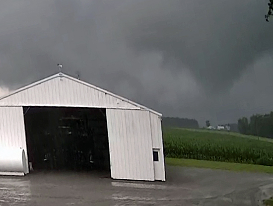
County Emergency Management Director Rick McCoy said an F-0 tornado (with F-5 the most powerful) touched down briefly a half-mile east of Mendon Road, between Brodnix and Wren Landeck roads, but was only on the ground for approximately a mile.
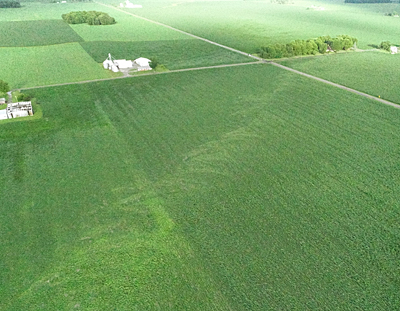
According to McCoy, eyewitness accounts, including videos and photos, as well as a damage assessment he conducted using a drone, showed damage in three cornfields and a woods, as well as minor damage at two residences at the corner of Mendon and Wren Landeck roads. After hitting the woods, between Mendon and Peter Collins roads, the tornado funnel disappeared at U.S. 127, just south of Hickory Sticks Golf Club.
McCoy said the tornado, which was 180 yards wide at one point, snapped a significant amount of corn and did very light damage to the two houses in its path. Some trees lost limbs, while several trees were damaged in the woods the tornado hit before lifting off the ground and dissipating.
No injuries were reported, he noted.
The tornado came as a surprise, McCoy said, since atmospheric conditions really weren’t conducive to tornado development, but mostly favored the development of heavy rain showers, which also occurred. The National Weather Service had cautioned that cold air funnels, which are caused by cold air aloft meeting a broad area of low pressure, and a counterclockwise spinning weather system. Cold air funnels rarely touch down, and, if they do, winds are only strong enough to toss light objects around.
However, the NWS confirmed that the county did get hit by an actual tornado, not a cold air funnel.
McCoy said he received the first phone call from the NWS at 6:51 p.m. advising him that a storm cell near Glenmore and another cell southeast of Van Wert were merging, producing very heavy rain and could result in a developing rotating storm system. The county EMA director then notified the Van Wert County Sheriff’s Office to be on the lookout for any developing funnel cloud.
At 7 p.m., a local storm spotter in Ohio City said he was told by several people that they had observed two funnels merge into one north of that village. The spotter said that, from his observations, nothing was on the ground at that time.
At 7:02 p.m., the sheriff’s office reported that several 9-1-1 calls reported a possible funnel near U.S. 127 south of Van Wert. However, none of the reports stated that a tornado had actually touched down.
Later, photos and videos began surfacing on social media and it was confirmed then that a tornado had actually touched down.
McCoy said the amount of rain is also causing problems throughout the county, noting that 6.25 inches of rain fell in the city of Van Wert, with higher amounts reported in the southern part of the county. Flooding and high water have been reported in several portions of the county.
POSTED: 06/23/18 at 6:49 pm. FILED UNDER: News