


McCoy: Damage from storm concentrated
DAVE MOSIER/independent editor
A storm that blew through the city of Van Wert on Thursday morning resulted in downed trees and some property damage that includes houses, businesses, and vehicles. Fortunately, no injuries were reported.
Van Wert County Emergency Management Director Rick McCoy noted that a potent Midwest storm that spawned tornadoes and flooding rains in other areas Wednesday evening raced across Indiana and Ohio Thursday morning. McCoy said he started tracking the storms in Indiana around 4 a.m. while they were producing damaging winds across that state.
As storms approached the Ohio-Indiana State Line at 5:44 a.m., the National Weather Service issued a severe thunderstorm warning, which McCoy broadcast in Van Wert County. The warning called for the possibility of winds gusting up to 70 mph, as well as rain and lightning.
The first indication of damaging winds, McCoy said, was when a semi-trailer rig was blown over near the intersection of U.S. 30 and Ohio 49 at 5:55 a.m. The storm entered the city of Van Wert at approximately 6 a.m. Thursday, but the most damaging winds were concentrated in just one city block near the Van Wert County Regional Airport.

McCoy said the path of the storm showed clear signs of a microburst, with winds in excess of 80 mph, while security cameras at the airport also indicated a gustnado (a form of tornado that forms on the ground from intense, fast-moving winds) within the microburst.
“The combination of these weather phenomena was enough to cause extensive damage in the area that it hit,” McCoy noted.
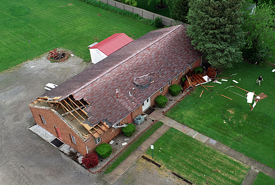
Damage began at the airport, where a Quonset building and one hangar were damaged. Across the road on Leeson Avenue a portion of the Pentecostal Way Church’s roof was torn off, while tree limbs were torn off and trees uprooted, while also doing minor roof damage to several houses in the area.
One house had heavier damage due to a large tree falling on the house.
The damage path continued to Shannon Street, where it continued cross to Crawford Street and Maple Avenue, damaging roofs and trees. After crossing Washington Street, the storm’s winds apparently intensified, with several buildings at Taylor Auto Sales damaged, then continued down Crawford Street to the east edge of town.
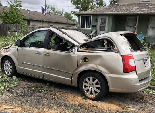
All of Crawford Street was closed due to the large number of big trees that were uprooted and limbs snapped off, which blocked the street in a number of places. Several vehicles were also crushed by trees, and several house had roof damage.
City crews have been working through the day on Thursday clearing trees and limbs and other debris from the streets, while the Van Wert Police Department and the EMA’s Community Emergency Response Team (CERT) provided traffic control in the area.
McCoy predicted that, with the wet weather pattern the area has been in, which is expected to continue, the advent of warmer temperatures will also likely mean severe storms are more likely. McCoy strongly urged area residents to purchase a NOAA Weather Alert Radio and also follow the EMA Facebook, as well as the EMA website. People also need to sign up for the Nixle alerts to receive EMA warnings on their cell phones.
POSTED: 05/23/19 at 2:50 pm. FILED UNDER: News