


McCoy: 4 tornadoes confirmed in county
DAVE MOSIER/independent editor
The National Weather Service confirmed on Thursday that four separate tornadoes touched down in Van Wert County in what is being called one of the worst tornado outbreaks in August, according to County Emergency Management Director Rick McCoy.
McCoy met with NWS officials from the Northern Indiana Office Thursday afternoon to conduct a site survey of damage done in the county on Wednesday. Of the four confirmed tornadoes, three were rated at the lowest storm strength (EF-0), while the fourth tornado was rated as an EF-1.
On Thursday morning, McCoy was able to do a flyover of the county, compliments of Van Wert County Regional Airport and local pilot Fred Pond. Air photos and video were also used to confirm the individual tornadoes and their damage paths in the county. NWS officials confirmed that information during ground surveys on Thursday afternoon.
According to the NWS, Wednesday’s tornadoes stemmed from a supercell thunderstorm that developed near Kokomo, Indiana, producing a large, violent tornado that struck that city, doing considerable damage. The storm kept producing tornadoes as it moved east through Indiana, which prompted the Storm Prediction Center to issue a tornado watch for areas south of Van Wert County in Ohio, as well as Adams County, Indiana.
McCoy said there were no indications that a severe storm system would develop on Wednesday, but initial predictions showed the storm crossing into Ohio south of Van Wert County. McCoy activated tornado spotters from the Mendon, Chattanooga, and Rockford fire departments as the storm moved across western Adams County in Indiana, telling them that tornadoes were still expected across northern Mercer County and would continue to head east.
However, at 5:54 p.m., the NWS issued a tornado warning for southeast Adams County and the extreme southwest portion of Van Wert County. McCoy then advised Ohio City and Willshire authorities to activate their tornado sirens.
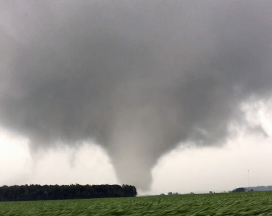
Just as two tornadoes were spotted near Monroe and Berne, Indiana, one of the storm systems moved toward Mercer County, while the other followed the path of the deadly F-4 tornado that hit Van Wert County on November 10, 2002, making a sharp left turn that brought it close to Willshire. McCoy said spotters indicated a large rotating wall cloud, but that no funnels had been spotted as the storm crossed into the county.
At 6:32 p.m. Wednesday, McCoy activated tornado sirens in Van Wert and the county villages, as the path of the storm seemed likely to bring it close to the city.
Spotters then reported a large tornado on the ground, with a second funnel aloft near German Church Road south of Convoy, with both moving northeast. The large tornado cross U.S. 224 and remained on the ground for four miles, while the second tornado continued northeast and touched down a quarter-mile west of the first funnel.
The first tornado lifted at Wolfcale Road, east of Dull Robinson Road, while the second funnel continued northeast for more than a mile and lifted at U.S. 30 and Richey Road.
McCoy said the storm began to recycle at about 6:43 p.m., with a supercell spinning up just north of the Van Wert city limits. From a large rotating wall cloud came a third tornado that touched down just east of U.S. 224, between Giffen and Convoy roads, and remained on the ground for a half mile.
At the same time, a fourth tornado touched down at Feasby Wisener Road, west of Middle Point-Wetzel Road. That storm, which was approximately a half-mile wide, continued on the ground heading northeast for two miles and lifted at the Van Wert-Paulding County line, just west of the Van Wert-Putnam County line, in the extreme northeast portion of the county.
Following the all-clear signal shortly after 7:15 p.m. Wednesday, American Red Cross damage assessment teams were dispatched to look for signs of storm damage. According to McCoy, six properties had damage to homes and barns, but no location had significant property loss.
“Luckily, the tornadoes were over a lot of rural cropland and spared many homes,” the EMA director said, while also noting that the Van Wert County Board of Commissioners issued an emergency declaration on Thursday.
McCoy thanked NWS officials for their timely storm warnings and also commended local spotters and emergency responders for their efforts during the storms.
“Van Wert County remains weather aware, as we have seen out share of storms,” McCoy said, noting that 31 tornadoes have hit Van Wert County since he became EMA director in 1990.
POSTED: 08/26/16 at 6:05 am. FILED UNDER: News